Are you searching for “Where Can I Fly Drones Near Me” in the USA, specifically around Washington, D.C., or other exciting locations? Look no further! This comprehensive guide, brought to you by flyermedia.net, will navigate you through the best drone flying spots, legal considerations, and essential tips for a safe and enjoyable experience. Whether you’re a recreational enthusiast or a commercial operator, understanding airspace regulations and local ordinances is key to responsible drone flight. Discover stunning locations and learn how to capture breathtaking aerial footage while staying compliant with all the rules.
1. Understanding Drone Laws: Recreational vs. Commercial
What are the key differences between flying a drone recreationally versus commercially?
Under FAA regulations, operating a drone falls into two categories: recreational and commercial. The primary distinction lies in the purpose of the flight. Recreational drone flights are purely for enjoyment, while commercial flights involve using a drone for business purposes, such as aerial photography for real estate or inspections.
To operate a drone commercially in the United States, you must obtain a Remote Pilot Certificate from the FAA. This certificate, often referred to as a Part 107 license, demonstrates that you understand the regulations and can safely operate a drone for commercial purposes. Recreational flyers, on the other hand, do not need this certificate but must adhere to the FAA’s recreational rules, which include flying below 400 feet, keeping the drone within visual line of sight, and avoiding restricted airspace.
1.1 How Does LAANC Simplify Airspace Authorization?
What is LAANC and how does it work?
LAANC, or Low Altitude Authorization and Notification Capability, is an automated system that allows drone pilots to request airspace authorization to fly in controlled airspace near airports. Previously, drone operators had to contact air traffic control directly, a process that could be time-consuming and cumbersome. LAANC streamlines this process, providing near-instantaneous approval in many cases.
LAANC is available through FAA-approved providers like Aloft and AirMap. Pilots can submit their flight plans through these apps, and the system automatically checks the request against pre-approved altitudes and locations. If the flight meets the criteria, authorization is granted almost immediately. However, if the flight exceeds the pre-approved limits, the request may require further review by air traffic control. LAANC is a game-changer for both recreational and commercial drone pilots, making it easier to comply with airspace regulations and safely integrate drones into the national airspace system.
1.2 Where Can I Find Up-to-Date Airspace Information?
What are the best resources for airspace information and temporary flight restrictions?
Staying informed about airspace restrictions is crucial for safe and legal drone operations. Several excellent resources provide up-to-date information, including temporary flight restrictions (TFRs). Apps like Aloft, Autopylot, and B4UFLY are indispensable tools for drone pilots. These apps display real-time airspace maps, showing controlled and uncontrolled airspace, no-fly zones, and active TFRs.
The FAA’s website is another valuable resource, offering detailed information about airspace regulations and TFRs. Additionally, websites like SkyVector provide sectional charts that visually represent airspace boundaries and other important aviation information. Regularly checking these resources before each flight is essential to ensure you are aware of any restrictions that may affect your planned operation. Always remember that ignorance of the law is not an excuse, and flying in restricted airspace can result in severe penalties.
2. Washington, D.C. Drone Laws: Navigating the No Drone Zone
What special drone laws apply in Washington, D.C.?
Washington, D.C., presents unique challenges for drone pilots due to its strict airspace regulations. The entire area is designated as a No Drone Zone, governed by a Special Flight Rules Area (SFRA) within a 30-mile radius of Ronald Reagan Washington National Airport. This means that flying a drone is generally prohibited within this zone without specific authorization.
The FAA has created this restricted area to protect national security interests. Drone pilots must be aware of these restrictions and take extra precautions to avoid violating the law. However, there are some limited exceptions for government agencies and authorized operators who obtain special permission from the FAA. For recreational flyers and most commercial operators, it’s best to avoid flying within the SFRA altogether. Always check the latest FAA guidance and local ordinances before flying in or near Washington, D.C., to ensure compliance.
2.1 What Are the Consequences of Violating Drone Laws in D.C.?
What are the penalties for illegal drone operation in the capital region?
Violating drone laws in Washington, D.C., can result in severe consequences, including hefty fines, confiscation of the drone, and even criminal charges. The FAA takes airspace violations very seriously, especially in sensitive areas like the nation’s capital. Penalties can range from civil fines of several thousand dollars to criminal prosecution for more egregious offenses.
In addition to federal penalties, local law enforcement may also impose fines and other sanctions for violating local drone ordinances. It’s important to remember that operating a drone irresponsibly can endanger people and property, further increasing the potential for legal repercussions. Drone pilots should always prioritize safety and compliance with all applicable laws and regulations. If you are unsure about the legality of a particular flight, it’s best to err on the side of caution and seek guidance from the FAA or a qualified aviation attorney.
2.2 Where Can I Find Official Information on the D.C. No Drone Zone?
Where can I find the most reliable information about the D.C. No Drone Zone?
The FAA’s website is the most reliable source of information about the D.C. No Drone Zone. The FAA provides detailed guidance on the restrictions, exceptions, and procedures for operating a drone in the National Capital Region. This includes maps of the SFRA, explanations of the rules, and contact information for FAA officials who can answer specific questions.
Additionally, you can find information on the FAA’s DroneZone website, which serves as a central hub for all things drone-related. It’s essential to consult these official sources regularly, as regulations and restrictions can change over time. Relying on unofficial sources or outdated information can lead to unintentional violations and potential penalties. Always verify the information with the FAA before conducting any drone operations in or near Washington, D.C.
3. Best Places to Fly a Drone Near Washington, D.C.
Where are some great locations for drone flying outside the D.C. No Drone Zone?
Despite the strict restrictions in Washington, D.C., several excellent locations nearby offer safe and enjoyable drone flying opportunities. These spots are located outside the SFRA and in uncontrolled airspace, where you can fly without needing prior authorization. Here are a few top picks:
3.1 Fountainhead Regional Park: A Natural Oasis
What makes Fountainhead Regional Park a good spot for drone pilots?
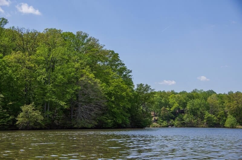
Fountainhead Regional Park, located in Fairfax Station, Virginia, is a sprawling 2,000-acre park that borders the Occoquan Reservoir. Its diverse landscape, featuring rolling hills, dense forests, and expansive water views, makes it an ideal location for drone pilots. The park sits in Class G uncontrolled airspace, meaning you don’t need to request permission to fly.
Drone enthusiasts will appreciate the vast open spaces and scenic vistas, perfect for capturing stunning aerial footage. The Occoquan Reservoir provides a beautiful backdrop for drone photography and videography, while the dense tree cover offers unique opportunities for challenging flight maneuvers. Additionally, the park features equestrian trails, mountain bike trails, and a fishing pond, adding to its appeal for outdoor enthusiasts.
 Fly Drone Fountainhead Regional Park
3.2 Sandy Point State Park: Coastal Views and Bay Breezes
Why is Sandy Point State Park popular among drone flyers?
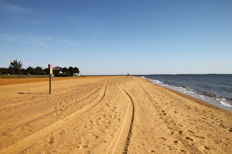
Sandy Point State Park, situated on the western end of Chesapeake Bay near Annapolis, Maryland, offers breathtaking coastal views and a refreshing bay breeze, making it a favorite spot for drone pilots. The park’s 786 acres include a beach overlooking Chesapeake Bay, providing stunning scenery for aerial photography and videography.
The iconic Sandy Point Shoal Lighthouse and the Chesapeake Bay Bridge offer unique focal points for drone shots. The park is located in Class G uncontrolled airspace, allowing for hassle-free drone flights. Whether you’re capturing the beauty of the bay, the elegance of the lighthouse, or the grandeur of the bridge, Sandy Point State Park provides a picturesque setting for drone operations.
 Fly Drone Sand Point State Park
3.3 Liberty Reservoir: Serene Waters and Lush Forests
What kind of scenery can I expect at Liberty Reservoir?
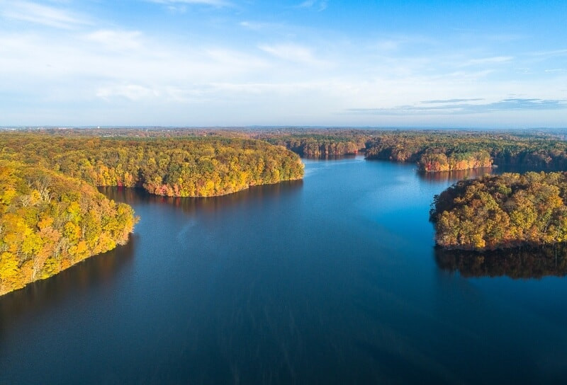
Liberty Reservoir, located west of Baltimore, Maryland, is a serene and expansive body of water surrounded by lush forests. With a surface area of 3,100 acres, the reservoir offers ample opportunities for capturing stunning aerial footage. The reservoir’s history adds to its allure, as it was once the site of a town called Oakland Mill before being submerged in 1947.
The Patapsco River feeds into the reservoir, creating a rich ecosystem that supports diverse wildlife. Drone pilots can capture breathtaking views of the water, the dense tree cover, and the surrounding landscape. The reservoir is located in Class G uncontrolled airspace, providing a safe and accessible environment for drone operations. Whether you’re seeking tranquil landscapes or captivating wildlife shots, Liberty Reservoir offers a wealth of possibilities.
 Fly Drone Liberty Reservoir
3.4 Greenwell State Park: Nature and History Combined
What unique features does Greenwell State Park offer for drone pilots?
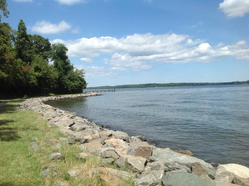
Greenwell State Park, located in Hollywood, Maryland, combines natural beauty with historical significance. The park sits on the Patuxent River and spans 596 acres, providing ample space for drone pilots to explore. The park’s diverse landscape includes open fields, wooded areas, and riverfront views, offering a variety of scenic opportunities.
A pier extends into the river, providing easy access for recreational activities and serving as an interesting subject for drone photography. The park is located in Class G uncontrolled airspace, making it a convenient and accessible location for drone flights. Greenwell State Park offers a unique blend of nature and history, providing a rich and rewarding experience for drone pilots.
 Fly Drone Washington D.C. Greenwell State Park
4. Essential Drone Flight Training Near Washington, D.C.
Why should I consider taking a drone flight training class?
If you’re new to drones or want to enhance your flying skills, consider taking a hands-on drone flight training class near Washington, D.C. These classes provide expert guidance on all aspects of drone operations, from pre-flight preparation to post-flight procedures. Experienced instructors will walk you through intelligent flight modes, safety protocols, and techniques for capturing the best shots or data.
During the class, you’ll have the opportunity to ask questions about regulations, software, flight operations management, checklists, and more. Whether you’re a recreational flyer or a commercial operator, drone flight training can help you become a more confident, skilled, and responsible pilot. Sign up for a hands-on drone flight training class in Maryland to take your drone skills to the next level.
5. Understanding Your Search Intent: “Where Can I Fly Drones Near Me?”
What are the common reasons people search for drone flying locations?
When someone searches for “where can I fly drones near me,” they typically have one of several intentions in mind. Understanding these intentions can help you tailor your content to meet their needs. Here are five common search intents:
5.1 Finding Legal and Safe Locations
Intent: Users want to identify areas where drone flying is permitted and safe.
Content: Provide a list of locations with clear indications of airspace restrictions, local regulations, and potential hazards. Offer tips for assessing the safety of a location.
5.2 Discovering Scenic Spots
Intent: Users seek visually appealing locations for capturing aerial photos and videos.
Content: Showcase locations with stunning scenery, such as parks, beaches, and landmarks. Include high-quality images and videos to inspire drone pilots.
5.3 Learning About Local Drone Laws
Intent: Users need information about drone regulations in their area.
Content: Provide a summary of local drone laws and ordinances, including restrictions, permit requirements, and penalties for violations. Link to official sources for more information.
5.4 Connecting with Other Drone Pilots
Intent: Users want to find communities or groups of drone enthusiasts in their area.
Content: List local drone clubs, online forums, and social media groups. Share information about drone events and meetups.
5.5 Seeking Training and Education
Intent: Users are looking for drone flight training classes or educational resources.
Content: Provide information about local drone flight schools, online courses, and workshops. Offer tips for improving drone flying skills and knowledge.
6. Optimizing Your Content for Google Discovery
How do I make my article stand out on Google Discovery?
To make your article stand out on Google Discovery, you need to optimize it for visual appeal, relevance, and engagement. Here are some key strategies:
6.1 Use High-Quality Images and Videos
Strategy: Visual content is essential for attracting attention on Google Discovery. Use high-resolution images and videos that showcase the beauty of the locations you’re featuring.
Example: Include stunning aerial shots of Fountainhead Regional Park, Sandy Point State Park, and other locations.
6.2 Craft Compelling Headlines and Descriptions
Strategy: Your headline and description are the first things users will see on Google Discovery. Make them attention-grabbing and relevant to the search query.
Example: “Discover the Best Drone Flying Spots Near D.C.: Legal, Safe, and Scenic”
6.3 Write Engaging and Informative Content
Strategy: Your content should be well-written, informative, and engaging. Provide valuable insights, tips, and recommendations that will keep users reading.
Example: Share personal anecdotes about drone flying experiences, offer insider tips for capturing the best shots, and provide detailed information about local regulations.
6.4 Optimize for Mobile Devices
Strategy: Google Discovery is primarily used on mobile devices, so make sure your article is mobile-friendly. Use a responsive design, optimize images for mobile viewing, and break up text into short paragraphs.
Example: Test your article on different mobile devices to ensure it looks and functions correctly.
6.5 Promote Your Article on Social Media
Strategy: Share your article on social media platforms like Facebook, Twitter, and Instagram. Use eye-catching visuals and compelling captions to drive traffic to your article.
Example: Create a short video showcasing the best drone flying spots near D.C. and share it on social media with a link to your article.
7. Incorporating E-E-A-T Principles for Trust and Credibility
How do I demonstrate Experience, Expertise, Authoritativeness, and Trustworthiness in my article?
Google’s E-E-A-T guidelines emphasize the importance of Experience, Expertise, Authoritativeness, and Trustworthiness in content creation. Here’s how to incorporate these principles into your article:
7.1 Experience: Share Your Own Drone Flying Experiences
Strategy: Share your own experiences flying drones in the locations you’re featuring. This will demonstrate that you have first-hand knowledge of the area and can provide valuable insights.
Example: “I’ve personally flown my drone at Fountainhead Regional Park and was amazed by the stunning views of the Occoquan Reservoir. The open spaces and dense tree cover made for a challenging but rewarding flight.”
7.2 Expertise: Demonstrate Your Knowledge of Drone Laws and Regulations
Strategy: Showcase your expertise by providing accurate and up-to-date information about drone laws and regulations. Cite official sources, such as the FAA, and explain complex topics in a clear and concise manner.
Example: “As a certified drone pilot, I’m familiar with the FAA’s Part 107 regulations and the specific restrictions in the Washington, D.C., area. It’s crucial to understand these rules to fly safely and legally.”
7.3 Authoritativeness: Cite Reputable Sources
Strategy: Establish your authoritativeness by citing reputable sources, such as the FAA, aviation experts, and drone industry publications. This will add credibility to your article and demonstrate that you’ve done your research.
Example: “According to the FAA, the National Capital Region is governed by a Special Flight Rules Area (SFRA) within a 30-mile radius of Ronald Reagan Washington National Airport, which restricts all flights in the greater DC area.”
7.4 Trustworthiness: Be Transparent and Accurate
Strategy: Build trust with your audience by being transparent and accurate in your content. Disclose any potential biases or conflicts of interest, and correct any errors promptly.
Example: “I strive to provide accurate and unbiased information about drone flying locations. If you spot any errors or have any questions, please don’t hesitate to contact me.”
8. Crafting an Effective Call to Action (CTA)
How do I encourage readers to take the next step and visit flyermedia.net?
A strong call to action (CTA) is essential for guiding readers to take the next step, such as visiting flyermedia.net. Here are some tips for crafting an effective CTA:
8.1 Make It Clear and Concise
Strategy: Your CTA should be clear and concise, telling readers exactly what you want them to do.
Example: “Visit flyermedia.net to discover more drone flying locations and aviation news.”
8.2 Highlight the Benefits
Strategy: Emphasize the benefits of taking the desired action. What will readers gain by visiting flyermedia.net?
Example: “Explore flyermedia.net for up-to-date aviation news, drone regulations, and exciting career opportunities in the industry.”
8.3 Create a Sense of Urgency
Strategy: Create a sense of urgency to encourage readers to act now.
Example: “Don’t miss out on the latest drone news and flight training opportunities! Visit flyermedia.net today.”
8.4 Use Action-Oriented Language
Strategy: Use action-oriented language that motivates readers to take action.
Example: “Discover your dream of flying today! Explore aviation careers and training programs at flyermedia.net.”
8.5 Place the CTA Strategically
Strategy: Place the CTA strategically throughout your article, such as at the beginning, middle, and end.
Example: “Ready to take your drone flying to the next level? Visit flyermedia.net to learn about drone flight training classes near you.”
9. Frequently Asked Questions (FAQ) About Drone Flying
What are some common questions people have about drone flying?
Here are ten frequently asked questions about drone flying:
9.1 Do I Need a License to Fly a Drone?
Answer: It depends. For recreational flights, you don’t need a license, but you must follow the FAA’s recreational rules. For commercial flights, you need a Remote Pilot Certificate (Part 107 license).
9.2 How High Can I Fly a Drone?
Answer: Generally, you can’t fly a drone higher than 400 feet above ground level.
9.3 Where Can’t I Fly a Drone?
Answer: You can’t fly a drone near airports, over people, or in restricted airspace without authorization.
9.4 What Is LAANC?
Answer: LAANC is an automated system that allows drone pilots to request airspace authorization to fly in controlled airspace near airports.
9.5 How Do I Register My Drone?
Answer: You can register your drone online through the FAA’s DroneZone website.
9.6 What Are the Penalties for Violating Drone Laws?
Answer: Penalties can include fines, confiscation of the drone, and even criminal charges.
9.7 Can I Fly a Drone at Night?
Answer: Yes, but you need to equip your drone with anti-collision lights and complete a night operations test.
9.8 How Do I Find Drone Flying Locations Near Me?
Answer: Use apps like Aloft, Autopylot, and B4UFLY to find legal and safe drone flying locations.
9.9 What Are the Best Drones for Beginners?
Answer: Popular beginner drones include the DJI Mini 2, DJI Mini 3 Pro, and Ryze Tech Tello.
9.10 Where Can I Learn More About Drone Flying?
Answer: Visit flyermedia.net for comprehensive information about drone flying, aviation news, and career opportunities.
10. Concluding Thoughts: Embark on Your Drone Flying Adventure with flyermedia.net
Ready to embark on your drone flying adventure? Whether you’re a seasoned pilot or just starting out, flyermedia.net is your go-to resource for all things aviation. Discover the best drone flying locations near you, stay up-to-date on the latest regulations, and explore exciting career opportunities in the industry.
From comprehensive guides to insightful articles, flyermedia.net provides the information and inspiration you need to take your drone flying to the next level. Don’t let the complexities of airspace regulations and local ordinances hold you back. With flyermedia.net, you can confidently navigate the world of drone flying and capture breathtaking aerial footage while staying safe and compliant.
Visit flyermedia.net today and unlock a world of aviation knowledge, drone flying tips, and career opportunities. Your dream of flying is just a click away!
Address: 600 S Clyde Morris Blvd, Daytona Beach, FL 32114, United States
Phone: +1 (386) 226-6000
Website: flyermedia.net