Navigating drone flying in Washington, D.C. can feel like traversing a no-fly zone, and in many respects, it is. The airspace surrounding the nation’s capital is among the most restricted in the U.S., governed by a Special Flight Rules Area (SFRA) within a 30-mile radius of Ronald Reagan Washington National Airport. This regulation significantly limits drone operations across the greater D.C. area.
If you’re a drone pilot living in or visiting Washington, D.C., understanding where you can legally and safely fly is crucial. This guide serves as your essential resource, detailing not just the best spots to launch your drone, but also the legal boundaries you need to respect. We aim to clarify the complex regulations, ensuring you remain compliant with both federal and local drone laws.
Understanding the Airspace: A Sectional Chart of Washington, D.C. Source: VFR Map
Understanding Drone Regulations in Washington, D.C.: Recreational vs. Commercial
Before you take to the skies, it’s vital to grasp the distinction between recreational and commercial drone operations under FAA regulations. This classification dictates the rules you must follow, regardless of whether you’re flying in Washington, D.C., or elsewhere.
A significant update for drone pilots is the automation of airspace authorization near airports. Previously, direct contact with air traffic control was mandatory within a five-mile radius of an airport. Now, the Low Altitude Authorization and Notification Capability (LAANC) system streamlines this process. Both recreational and commercial pilots can utilize LAANC to request airspace authorization in controlled airspace around and above numerous airports. For operations in Class B, C, D, or E controlled airspace, obtaining prior authorization is mandatory via LAANC or FAADroneZone in areas where LAANC isn’t available.
Throughout this guide, we will specify whether our recommended flying locations fall within controlled or uncontrolled airspace, simplifying your flight planning.
To stay informed about real-time airspace conditions, including Temporary Flight Restrictions (TFRs), leverage free mobile apps such as Aloft, Autopylot, or B4UFLY. These tools provide essential, up-to-date information directly to your fingertips.
Considering professional drone operations? Earning your FAA Part 107 certification is a crucial step. This certification allows you to operate drones commercially and generate income from your drone skills. Explore comprehensive online training courses at Drone Pilot Ground School to kickstart your professional drone career.
Federal regulations are just one piece of the puzzle. What about local drone laws specific to Washington, D.C.?
Washington D.C. itself has unique drone restrictions. It’s designated as a No Drone Zone by the FAA. The National Capital Region’s SFRA imposes strict limitations on all flights, including drones, within that 30-mile radius of Ronald Reagan Washington National Airport. For detailed insights into the D.C. No Drone Zone, refer to the FAA’s dedicated page. Furthermore, consulting local Washington D.C. drone ordinances is advisable, as outlined in resources like this guide on drone laws in Washington D.C.. When uncertainties arise, prioritizing good judgment and FAA guidelines is always recommended.
Disclaimer: The content provided here is for informational purposes only and should not be considered legal advice. For specific legal counsel or if you have further questions, please reach out to support[at]uavcoach[dot]com.
Discovering Drone-Friendly Locations Near Washington, D.C.
Despite the restricted airspace closer to Washington, D.C., several excellent locations just outside the immediate vicinity offer drone pilots legal and scenic flying opportunities. Our curated list prioritizes locations in uncontrolled, Class G airspace, eliminating the need for airspace authorization. We’ve also highlighted spots with designated sUAS/remote aircraft fields for dedicated drone enthusiasts.
Here are our top recommendations for where to fly drones near Washington, D.C.:
1 — Fountainhead Regional Park: A Nature Escape for Drone Pilots
10875 Hampton Rd, Fairfax Station, VA 22039
- Airspace Class: Class G — Uncontrolled
- Airspace Map: https://b4ufly.aloft.ai/?lat=38.717070&long=-77.335618
Fountainhead Regional Park, sprawling across 2,000 acres along a Potomac River tributary, presents a haven for drone pilots. Its diverse landscape, featuring rolling hills, dense forests, and the scenic Occoquan Reservoir, provides stunning aerial perspectives. Beyond drone flying, the park offers equestrian and mountain bike trails, a mini-golf course, and a fishing pond, making it a versatile destination. Drone enthusiasts will particularly appreciate the open spaces, water features, and lush tree canopies, ideal for capturing breathtaking footage.
Kayaking at Fountainhead Regional Park, offering beautiful waterscapes for drone photography. Source: Boris Burnayev
2 — Sandy Point State Park: Coastal Drone Flights with Bay Bridge Views
1100 E College Pkwy, Annapolis, MD 21409
- Airspace Class: Class G — Uncontrolled
- Airspace Map: https://b4ufly.aloft.ai/?lat=39.012383&long=-76.399090
Nestled on the western edge of Chesapeake Bay, Sandy Point State Park encompasses 786 acres of scenic beauty. Home to the historic Sandy Point Farmhouse and the iconic Sandy Point Shoal Lighthouse, this park offers a rich tapestry of sights. The beach along Chesapeake Bay and panoramic views including the Chesapeake Bay Bridge create a stunning backdrop for drone photography and videography.
Aerial view of Sandy Point State Park, showcasing the beach and Chesapeake Bay Bridge, ideal for drone footage. Source: Mr.TinDC
3 — Liberty Reservoir: Capture Expansive Water and Wildlife from Above
5685 Oakland Rd, Eldersburg, MD 21784
- Airspace Class: Class G — Uncontrolled
- Airspace Map: https://b4ufly.aloft.ai/?lat=39.396484&long=-76.884540
Located west of Baltimore, Maryland, Liberty Reservoir sprawls across 3,100 acres. Rich in history, the reservoir’s location was once Oakland Mill town before being submerged in 1947 to create this vast water body, fed primarily by the Patapsco River. Today, Liberty Reservoir offers drone pilots expansive water views, dense surrounding forests, and abundant wildlife, perfect for capturing impressive aerial videos and photographs.
 fly drone liberty reservoir
An aerial shot of Liberty Reservoir, displaying its vast waters and surrounding natural landscapes, perfect for drone exploration. Source: Matthew Binebrink
4 — Greenwell State Park: Riverfront Drone Flying Amidst Farm Fields
25420 Rosedale Manor Ln, Hollywood, MD 20636
- Airspace Class: Class G — Uncontrolled
- Airspace Map: https://b4ufly.aloft.ai/?lat=38.626308&long=-76.672915
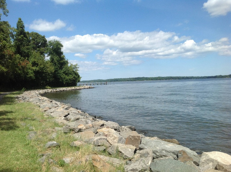
Greenwell State Park, situated on the Patuxent River in Hollywood, Maryland, provides 596 acres of open space ideal for drone operations. A pier extending into the river enhances recreational opportunities and offers unique perspectives. The picturesque blend of river views, the pier itself, and adjacent farm fields creates a tranquil and visually appealing environment for drone flights.
 fly drone washington D.C. greenwell state park
Greenwell State Park pier and riverfront, presenting a serene location for drone pilots seeking scenic shots. Source: activerain
Enhance Your Drone Skills with Local Flight Training
For those new to drone piloting or aiming to refine their skills, hands-on drone flight training is invaluable. In the vicinity of Washington, D.C., comprehensive drone flight training classes are available in Maryland. These courses, starting from 2-hour sessions, are led by experienced instructors who guide you through pre-flight checks, in-flight maneuvers, and post-flight procedures. You’ll gain practical experience with intelligent flight modes and learn crucial safety protocols to ensure responsible and effective drone operation. These training sessions also offer a platform to address your queries on regulations, software, flight operations management, checklists, and more, ensuring you are well-prepared for every flight.